Lessico
Abraham
Oertel
Abramo Ortelio
![]()
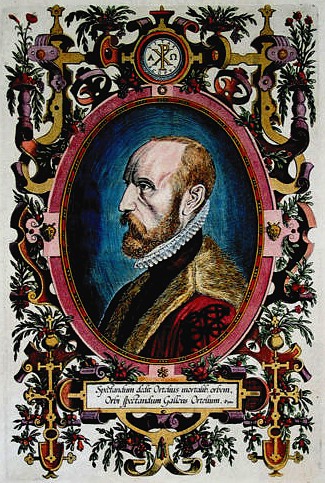
Abramo Ortelio: nome italianizzato del geografo e cartografo fiammingo Abraham Oertel (Anversa, 2 aprile 1527 – 28 giugno 1598). Ortelius fu il grande fondatore della cartografia fiamminga con Mercatore, nome italianizzato di Gerardus Mercator, il cartografo e geografo fiammingo Gerhard Kremer (Rupelmonde 1512-Duisburg 1594).
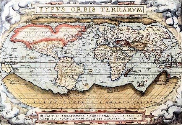
Dopo avere studiato greco, latino e matematica, Oertel si stabilě ad Anversa - il grande porto delle Diciassette Province - come libraio e cartografo. Viaggiň molto e pubblicň in 1564 una carta del mondo in 8 fogli che conobbe un grande successo. Il suo modo di lavorare era sensibilmente differente del suo rivale e amico Mercatore: Ortelius redigeva le carte per mezzo dei suoi contatti professionali o amichevoli con i cartografi europei. Nel 1564 pubblicň una carta del mondo (Typus Orbis Terrarum) in otto fogli.
Theatrum Orbis Terrarum - 1570
Venticinque anni prima dell'atlante di Mercatore, fece incidere da Franz Hogenberg la sua collezione di carte in una stessa scala (1570) che fu pubblicata sotto il titolo di Theatrum Orbis Terrarum che costituisce in effetti il primo atlante, una pubblicazione che conobbe quattro ristampe nei suoi primi dieci anni dall'uscita. In totale, il Theatrum fu pubblicato in sette lingue e trentasei edizioni. Ortelius fu anche il primo a citare le sue fonti per le carte, menzionando i nomi dei cartografi all'origine delle notizie cartografiche.
Ortelius pubblicň inoltre parecchie carte storiche, alcune delle quali furono inglobate nel Theatrum. Tra 1579 e 1606 fu pubblicato il suo Parergon Theatri, contenente una riproduzione della Tabula Peutingeriana, nome latino dato a una copia del sec. XII o XIII su rotolo pergamenaceo lungo 6,80 m di un antico itinerario figurato a colori dell'Impero romano conservata alla Biblioteca Nazionale di Vienna e che trae il nome dall'umanista tedesco Konrad Peutinger (Augusta 1465-1547) che la pubblicň parzialmente.
Nel 1570 Ortelius ottenne il monopolio per gli atlanti, il che impedě in particolare a Gerardo di Jode, che aveva pubblicato la carta del mondo nel 1564, di pubblicare il proprio atlante prima del 1578.
Abraham Ortelius (Abraham Oertel) (Antwerp April 2, 1527 – June 28, 1598) was a cartographer and geographer, generally recognised as the creator of the first modern atlas. He was born in Antwerp in what is now Belgium. A member of the influential Ortelius family of Augsburg, he traveled extensively in Europe. He is specifically known to have traveled throughout the Seventeen Provinces; south and west and north and east Germany (e.g., 1560, 1575–1576); France (1559–1560); England and Ireland (1576), and Italy (1578, and perhaps twice or thrice between 1550 and 1558).
Beginning as a map-engraver, in 1547 he entered the Antwerp guild of St Luke as afsetter van Karten. His early career is that of a businessman, and most of his journeys before 1560 are for commercial purposes (such as his yearly visits to the Frankfurt book and print fair). In 1560, however, when travelling with Mercator to Trier, Lorraine and Poitiers, he seems to have been attracted, largely by Mercator’s influence, towards the career of a scientific geographer; in particular he now devoted himself, at his friend’s suggestion, to the compilation of that atlas, or Theatrum Orbis Terrarum (Theatre of the World), by which he became famous.
In 1575 he was appointed geographer to the king of Spain, Philip II, on the recommendation of Arias Montanus, who vouched for his orthodoxy (his family, as early as 1535, had fallen under suspicion of Protestantism). In 1578 he laid the basis of a critical treatment of ancient geography by his Synonymia geographica (issued by the Plantin press at Antwerp and republished in expanded form as Thesaurus geographicus in 1587 and again expanded in 1596 In this last edition, Ortelius considers the possibility of continental drift, a hypothesis proved correct only centuries later).
In 1596 he received a presentation from Antwerp city, similar to that afterwards bestowed on Rubens. His death, on June 28, 1598, and burial, in St Michael’s Prćmonstratensian Abbey church in Antwerp, were marked by public mourning. Quietis cultor sine lite, uxore, prole, reads the inscription on his tombstone.
Maps
In 1564 he completed a "mappemonde", eight-leaved map of the world, which afterwards appeared in reduced form in the Theatrum. The only extant copy of this great map is in the library of the University of Basle (cf. Bernoulli, Ein Karteninkunabelnband, Basle, 1905, p. 5). He also published a two-sheet map of Egypt in 1565, a plan of Brittenburg Castle on the coast of the Netherlands in 1568, an eight-sheet map of Asia in 1567, and a six-sheet map of Spain before the appearance of his atlas.
Theatrum Orbis Terrarum
On May 20, 1570, was issued, by Gilles Coppens de Diest at Antwerp, Ortelius’ Theatrum Orbis Terrarum, the "first modern atlas" (of 53 maps). Three Latin editions of this (besides a Dutch, a French and a German edition) appeared before the end of 1572; twenty-five editions came out before Ortelius' death in 1598; and several others were published subsequently, for the atlas continued to be in demand till about 1612. Most of the maps were admittedly reproductions (a list of 87 authors is given in the first Theatrum by Ortelius himself, growing to 183 names in the 1601 Latin edition), and many discrepancies of delineation or nomenclature occur. Errors, of course, abound, both in general conceptions and in detail; thus South America is initially very faulty in outline, but corrected in the 1587 French edition, and in Scotland the Grampians lie between the Forth and the Clyde; but, taken as a whole, this atlas with its accompanying text was a monument of rare erudition and industry. Its immediate precursor and prototype was a collection of thirty-eight maps of European lands, and of Asia, Africa, Tartary and Egypt, gathered together by the wealth and enterprise, and through the agents, of Ortelius’ friend and patron, Gilles Hooftman, lord of Cleydael and Aertselaer: most of these were printed in Rome, eight or nine only in Belgium.
In 1573 Ortelius published seventeen supplementary maps under the title Additamentum Theatri Orbis Terrarum. Four more Additamenta were to follow, the last one appearing in 1597. He also had a keen interest and formed a fine collection of coins, medals and antiques, and this resulted in the book (also in 1573, published by Philippe Galle of Antwerp) Deorum dearumque capita … ex Museo Ortelii (reprinted in 1582, 1602, 1612, 1680, 1683 and finally in 1699 by Gronovius, Thesaurus Graecarum Antiquitatum. vol. vii).
The Theatrum Orbis Terrarum inspired a six volume work entitled Civitates orbis terrarum edited by Georg Braun and illustrated by Frans Hogenberg with the assistance of Ortelius himself.
Later maps
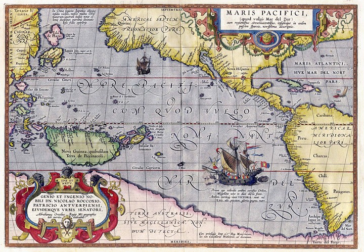
In 1579 he brought out his Nomenclator Ptolemaicus and started his Parergon (a series of maps illustrating ancient history, sacred and secular). He also published Itinerarium per nonnuilas Galliae Belgicae partes (at the Plantin press in 1584, and reprinted in 1630, 1661 in Hegenitius, Itin. Frisio-Hoil., in 1667 by Verbiest, and finally in 1757 in Leuven), a record of a journey in Belgium and the Rhineland made in 1575. In 1589 he published Maris Pacifici, the first dedicated map of the Pacific to be printed. Among his last works were an edition of Caesar (C. I. Caesaris omnia quae extant, Leiden, Raphelingen, 1593), and the Aurei saeculi imago, sive Germanorum veterum vita, mores, ritus et religio. (Philippe Galle, Antwerp, 1596). He also aided Welser in his edition of the Peutinger Table in 1598.
![]()